Heading north to Madison, WI in a couple hours, meeting up with a couple chasers there and heading up to Minnesota for tomorrow's setup. Concerned about the lack of appreciable upper level/500mb jet support, but it's close enough to be worth a play.
Ended up with about 3,400 miles over the last few days...brief tornado captured in eastern KS, nice structure all three days, but overall fairly underwhelming. Be nice to change that the next couple days...see if we're able to pull some magic out of the warm sector tomorrow!
Monday, April 30, 2012
Wednesday, April 25, 2012
Chase update - 4-26/4-27-2012
Currently in West Memphis, TN, getting the Jetta some upgrades for what looks like a significant tornado threat over SE CO/SW KS/NW OK late tomorrow afternoon. Don't have time to post an updated forecast, but what I posted before is pretty much on track. Blasting west to OKC for the night, then NW tomorrow afternoon!
After that, looks like the 27th is going to be a warm front play in central MO...head up that way, then home Friday night/Saturday morning. Could be a couple of great days!
After that, looks like the 27th is going to be a warm front play in central MO...head up that way, then home Friday night/Saturday morning. Could be a couple of great days!
Saturday, April 21, 2012
Forecast: 4/27 - 4/28/2012
The long-range GFS model has been showing potential for severe weather/tornadoes towards the end of this coming week...here's a quick overview of the situation.


For the 27th, a strong dryline is forecast to set up over eastern Colorado down through west Texas.

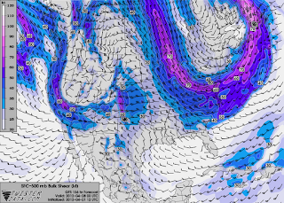
500mb jet aoa 50 kts isn't fantastic, but will support supercell storm structures.

Bulk shear values at over 60 kts are forecast...more than sufficient for strong rotating supercells.

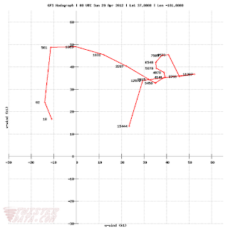
Gorgeous hodo...definitely suggests the possibility of strong tornadoes.
Only limiting factors with the GFS are CAPE and the possibility of warmer temps advecting in at 925 mb and creating a capping inversion...GFS normally underestimates CAPE, though, so that doesn't appear to be an issue. The cap, on the other hand, looks like it may be an issue both on the 27th and the 28th...we'll see how it plays out.
Afa the 28th is concerned, the setup is basically the same.

Dryline looks almost exactly the same...even in the same place as the day before! Biggest difference here is the hint of a low center developing in SE Colorado...if this happens, it should enhance directional shear in SW KS, especially.

Again, an absolutely gorgeous hodo right on the SW KS/OK border...if this verifies, strong tornadoes will again be a concern.

GFS is a bit more generous with the CAPE on the 28th...2500+ is more than enough to get sups rolling.
In essence, while still a ways out, and subject to change drastically...a rudimentary look at the weather models are sufficient to show that a significant severe weather outbreak could occur late next week over the southern plains...I'll be on leave for a couple weeks starting this week, so I'll definitely be playing these setups!
Tuesday, April 17, 2012
Sunday, April 15, 2012
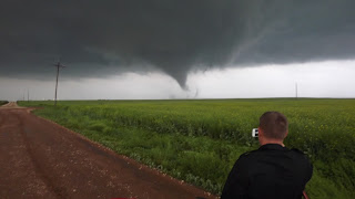
5 tornadoes! - 4/14/12 KS/OK tornado outbreak
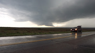
Snagged 5 tornadoes today, including twice where we had two on the ground at once. Intense day...awesome structure led to frustration early on as the first 5 storms just couldn't do it...then ended up getting chased down the worst roads I've ever driven in by an incredible 400 yard wide multi-vortex tornado within 100 yards. Working on video now - it's sick. Here's a few shots...didn't get good stills of the tornadoes - just too much going on.
Incredible wall cloud in SW KS.

Tornado #1 back in the rain...ended up being a gorgeous elephant trunk.

Close-up of the wall cloud.

One of the tornadoes in Major county, OK.
Video to follow!

Incredible wall cloud in SW KS.

Tornado #1 back in the rain...ended up being a gorgeous elephant trunk.

Close-up of the wall cloud.

This was our last shot before all hell broke loose...closest I've ever come to being hit on a chase. 100 yards.

One of the tornadoes in Major county, OK.
Video to follow!
Friday, April 13, 2012
Update - Chase Plans, 4-14-12
Tomorrow is one of those days that just looks absolutely scary...forecast I posted below has verified in every regard - in fact, it's actually gotten stronger. Leaving in a couple hours - 14 hour drive through the night to OKC, get there about 4 AM, sleep for 5 hours, thinking about heading up to Wellington, KS after that. Going to have to marathon it back to Pensacola Saturday night/Sunday...should be able to pull it off non-stop.
OKC metro - Wichita metro and points in between...wow. Loaded gun setup, potentially historic tornado outbreak unfolding. One of those chase days where you have a sick feeling in your stomach as you watch it all come together. Area up at the triple point in NE/IA also looks dangerous.
I'll post some nowcast updates as data permits...time to make it 3-3 for wedges on high risk days.
Sunday, April 8, 2012
Forecast - 4-14-2012
As per the morning's GFS runs, potential exists for a large-scale tornado outbreak Saturday, April 14th. Currently looking at a target just west of OKC...could shift as the smaller-scale models come into focus towards the end of the week.

Taking a look at the surface wind/temps map, two areas of interest pop out, associated with the lows centered in eastern Colorado and SW Minnesota.

Map of the surface moisture/dewpoints show a well-defined dryline extending from southern MN all the way south to Mexico.

Absolutely gorgeous sickle hodograph taken at 00Z just west of the OKC metro area. Bulk shear values and SRH (storm relative helicity) are going to be more than sufficient if this verifies.

Nice pocket of 2500-3000 CAPE (convective available potential energy) right in my target area...CAPE will be sufficient in the secondary area of interest in NC IA/SC MN, to boot.
In essence, Saturday has the potential to be a large-impact, dangerous tornado outbreak ranging from Texas to Minnesota. Attm, expecting to be just northwest of the OKC metro area Saturday afternoon...obviously, that could change as this gets closer to fruition. My official 2 week "chasecation" begins April 17th...will be chasing every setup!
Subscribe to:
Posts (Atom)