Sunday, March 5, 2017

2-28-17 Washburn, IL Tornadoes

Nice start to the season with 3 tornadoes from Washburn, IL and points east. Obviously rusty, getting stuck blasting north to the river crossing at Lacon and ending up about 10-15 miles behind the first tornado when it touched down. Recovered in time to get within a mile or so of the final tornado of the day.

Washburn EF-3 from way too far away


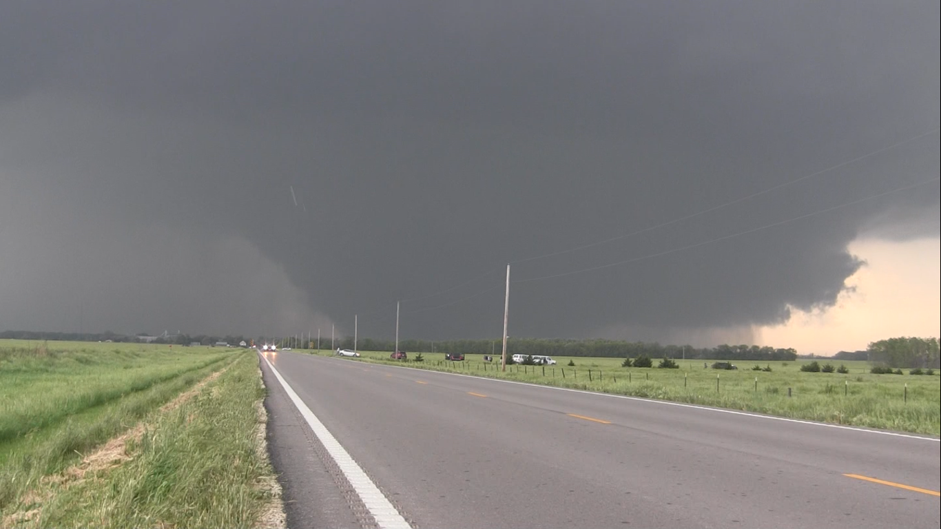
Final tornado video...crazy getting through the tree line just in time to see the barn roof get lifted. 

All in all, best start to a season I've ever had, getting on the board on the first chase and some solid daytime IL tornadoes. RFD was luckily very dry, lending the tornadoes to surprisingly good visibility from the northwest...rarely see that. 

Friday, June 10, 2016

Dodge City, KS Tornadoes - 5/24/2016

After the Spearman tornadoes on the 22nd, we had a bust day on the 23rd. Bit south into the eastern Texas panhandle instead of sticking with our initial target of Woodward, OK, and missed a couple nice tornadoes up there. Did hit a nice supercell dying off right at sunset, and Mike got a nice
lightning shot with his new camera

.

Ended up in Garden City, KS for the night, wanting to be north far enough to play Colorado the next day if the setup warranted. Two target day, with an outflow boundary/dryline intersection in SW Kansas and the DCVZ looking to blow up with 3k cape nosing into Denver. Decided on the OFB, and moved south just across the border into Oklahoma. As the target became better defined, Mike and I drifted north, and got on a nice supercell from the towering cumulus stage. 

We got under the updraft base as it consolidated into one dominant updraft. Was very high-based at this point, and didn't expect much to happen for awhile. We were very surprised when it went tornado warned. 


Within about 20 minutes, though, the base lowered dramatically, inflow started picking up, and it was pretty obvious it would be tornado time in a few minutes. 


Absolutely stunning, in the best chase terrain in the country. A few minutes later, a large cone funnel developed on the left side, and the first tornado touched down. 


This tornado would've made most chase days by itself, but it wasn't even close to being the most impressive this storm would produce. It lifted briefly as it ingested another area of circulation, then planted again as an incredible stout stovepipe. 


At this point, total insanity began. Multiple times with 2 tornadoes on the ground at the same time. 


Mike got this shot of me...intermittent vortices to the right, beautiful cone to the left. Absolute dream storm. 


At some point, I may try to salvage some of the video we shot after this, but it was all shot while driving and navigating around both Dodge City and the storm chaser traffic on highway 283, so it's pretty shaky. Several more tornadoes touched down, though, including one very large one to the northwest of Dodge City. It's still unbelievable looking back over the footage and realizing it actually happened...just a spectacular, slow moving cyclical tornadic supercell rooting on an outflow boundary and taking advantage of the added vorticity. Here's the footage!


Sunday, June 5, 2016

Spearman, TX Tornadoes - May 22, 2016

Finally getting around to chase logs for the last week of May...pretty incredible. Finally seeing the record El Nino reverse, and great tornado events on the Plains have returned.

Met Mike Brady in STL around 7:15 the night before, drove to Norman, arriving at about 3 AM, and stayed at Brandon Sullivan's place to catch a few hours of sleep. Left Norman about 8 AM, grabbed Braum's (important) for lunch, and continued to the big Love's truck stop 27 miles east of Amarillo. 

As we had driven out, the target area had become more clearly defined. A dryline was sharpening up in far west Texas, with deep 70's dews and high instability ahead of it. Forcing mechanisms were poorly defined, as would be the case all week, with subtle shortwaves embedded in broad SWerly flow. As we sat at the Love's, we watched the dryline sharpen to the west, and convective initiation occurring to our north and south. The north storm looked better, and would keep us in play for the later show on the dryline, so we went up to take a look. 

The north storm looked like ass. High-based, struggling, etc. We thought about blasting south to what now looked like much better storms in a better environment, and even left the north storm for about 10 minutes, but ultimately decided to stick with it after noticing a small wall cloud and RFD clear slot wrapping around. The storm cycled 2 or 3 times, with decent rotation, but nothing really impressive. 

About this time, we noticed 5-6 updrafts blowing up to the south, and realized that we'd have to wait through some inflow-region cell mergers. We got east, out ahead of the storm, and waited for about an hour or two for these to complete, noting penny sized hail in one of the updrafts as it was ingested into the main storm. After the cell mergers were complete, we headed back west, and saw a nice base with a developing wall cloud. We got west towards it, found a gravel road south that wasn't too washed out, and parked to watch it. Inflow quickly picked up to the 40+ mph range, and I tweeted a pic to the Amarillo NWS office. 


A couple minutes later, Mike yelled something, and I looked up. A poorly-defined stovepipe tornado had emerged from the rain behind this wall cloud. I tweeted another report to Amarillo as Mike filmed, all while the first wall cloud we had noticed ramped up. 

Within a couple minutes, there were two tornadoes on the ground, the new wall cloud continuing to organize and drop intermittent tornadoes as the ongoing main tornado started to rope out spectacularly. 


After this tornado dissipated, we headed north and east to stay ahead of the RFD surge now cutting around the second, now primary mesocyclone. It continued to drop small, intermittent tornadoes, but as we headed east the largest tornado formed. 


Grainy shot as we were still driving, but seconds later we pulled off into a gravel lot on the north side of Texas highway 281, pulling in next to Tony Laubach. Here, we watched the entire meso plant as a large, dusty wedge between 1-2 miles north of the highway. 


At times when the wedge wasn't fully condensated, smaller subvortices would form inside the parent circulation.


As the RFD precip swung around towards us, we kept heading east. The tornado recondensated nicely several times during this period, once fairly close to us as a classic cone. 


All told, including a couple of satellites, probably 4-5 tornadoes in about a 45 minute span from this supercell. Incredible start to the trip, scoring my first really photogenic Texas tornadoes and we headed to Amarillo for the night to stage for the next day. 


Saturday, June 21, 2014

June 14th, 2014 chase and 2014 season wrap

Flew from Atlanta into Kansas City early Saturday morning to chase with Brady. Ended up on the Stockton, KS cell...first time I've been in that area since I broke down there in 2011. Beautiful supercell that ramped up hard after dark and produced a couple nocturnal tornadoes. Nothing like what would happen later in the week, but there was no way to make it work to be up there for that, unfortunately.

Here's a collection of the best shots I got this year....tough year. What a grind. All told, somewhere between 12 and 13,000 miles, chased Arkansas, Mississippi, Oklahoma, Kansas, Missouri, Nebraska, Iowa, Wyoming, and Colorado, and ended up in a few more states than that.

Incredible stacked plates supercell near Brooksdale, MS. This storm had earlier produced the EF-4 tornado that impacted Louisville, MS.


Stovepipe tornado near Yazoo City, MS on April 28th.


Mammatus over Oklahoma City on May 8th.


Loaded up and headed north towards storms on May 10th.


Radar grab as I get into position on a big hailer in NE KS on May 10th.


My Jetta parked in front of a developing supercell in NE KS on May 10th.


Crazy inflow tail/wall cloud structure on the beast storm in SE Nebraska on Mother's Day, May 11th.


Monster EF-3 1.5 mile wide wedge tornado near Beaver Crossing, NE on May 11th.


Gorgeous LP supercell near Martin, NE on May 19th.


Nice LP storm SW of Torrington, WY on May 20th.


Rapidly rotating wall cloud near Denver International Airport on May 21st.


Insane HP beast near Denver International Airport on May 21st.


Sculpted meso near Stockton, KS on June 14th.


Crazy mothership structure just across the NE border near Red Cloud, June 14th.


Large wall cloud after dark east of Hastings, NE, right before dropping a couple of brief tornadoes.


Hopefully fall season throws us some bones...everyone who couldn't play Nebraska/South Dakota this week sure needs it. It's a wrap for Spring 2014. 4 tornadoes, and a feeling of unfinished business. Redemption will come.

Monday, May 12, 2014

Monster Nebraska Wedge Tornado - 5-11-2014

Tough day yesterday with the HP monster in SE NE, but pulled out a couple tornadoes, most notably this big wedge! 


Wednesday, April 30, 2014

Chase Recap - April 26-28th, 2014.

Rough notes to look back on for when I can actually do a day-by-day summary...First big trip of the year, and pulled down at least two, and possibly 3 tornadoes. Left Meridian at 6 PM the night of the 25th, and drove to Norman, Oklahoma. Stayed with Brandon Sullivan. Sat in Norman most of the day, noted strong mixing out of the dewpoints in SW OK from the low 60's to the low 50's. Realized early on this wasn't a chase setup, and left for Arkansas around 4 PM. Stayed in Alma, AR for the night.

The 26th was insane. High risk upgrade at 3 PM, volatile environment. Watched storm from Pine Bluff for a good chunk of the day. Moved south and west for a bit, then back north to Little Rock. Sat on an overpass on the west side of Little Rock and watched the storm that would produce the Maumelle/Mayflower/Vilonia monster wedge tornado evolve. Moved east and then north, encountering insane inflow winds and an LCL at ground level pulling into the tornado, and got a rough view of the tornado as it entered Vilonia. Chased on up to around Searcy, then gave it up for the night. Drove back home to Meridian that night, arrived about 3:30 AM.

Up at 7, went to work at 8, got the day off, then blasted west to Canton, MS. Waited for storms to mature, and moved in on the Yazoo City storm. Caught the stovepipe phase of the tornado, then blasted east, trying to get ahead of the Louisville storm. Couldn't do it til I got to Starksville and dropped down 45, encountering debris falling from the sky for about 10 minutes. Amazing stacked plates supercell with a large ground-scraping wall cloud...difficult to tell if it was on the ground with the trees, so waiting to see the damage survey. Ended back home in Meridian after dark.

All told, 2,156 miles, 6 states, 2 confirmed tornadoes, and a great start to the season. I'll be on vacation for the entire month of May...plains season should ramp up soon!

Monday, April 28, 2014

Yazoo City, MS Stovepipe Tornado - April 28, 2014

Chased the 2nd day of a huge Dixie Alley tornado outbreak, and pulled down a nice stovepipe tornado around Yazoo City, MS!


Vilonia, AR Violent Wedge Tornado - April 27, 2014

Insane weekend. Cap bust in Oklahoma on Saturday, and the toughest chase of my life on Sunday, culminating in a shot of the rain-wrapped wedge just before it impacted Vilonia, Arkansas. Video will be up later in the week, as today looks to be another violent day closer to home. Here's a couple shots.


This is a raw screenshot from the footage. Multiple power flashes seen seconds before pinpointing the exact location.


And with the contrast enhanced. Unfortunately, at least 16 fatalities have been reported from this tornado. Catastrophic damage all through the region...prayers go out to all those affected.

Wednesday, October 23, 2013

2013 Year in Review

What a year! Was able to take my entire vacation during the only active period for tornadoes this year, scoring 7 tornadoes on 4 separate days in May. Pulled down two of the best pieces of footage I've ever taken, and got extremely close to the prettiest tornado I've ever seen on May 18th, 2013.

I started on May 16th, chasing with Jonathan Williamson, Alec Scholten, and Nick Nolte. We chased an uneventful "day before the day" type setup on the 17th in South Dakota, with only a weird leading-edge funnel on a squall line. Also experienced a heatburst as a thunderstorm collapsed on top of us.

From then is was south, through Nebraska to southwest Kansas. We bit on the first storm of the day since nothing else was initiating, and, even though we hung with the north storm for about 10-15 minutes too long, we managed to escape south and punch through the core of the Rozel storm. We saw 3 tornadoes over the next 40 minutes - one EF-4, followed by two amazingly photogenic tornadoes just east of the town.

The next day was a bust, plain and simple. We elected to play the outflow boundary and eastward propogating gravity waves on the OK/KS border. Let the initial storm (that produced a large tornado in the Wichita suburbs) go, snagged a brief tornado near Caldwell, KS - then attempted a mad dash south towards the monster tornadoes ravaging the towns east of Oklahoma City.

As we entered the south side of Stroud, Oklahoma, we were stopped by a train. Frustrated, we barely noticed the debris starting to fall out of the sky. When we eventually looked up, the sky was filled with insulation and other debris drifting towards the ground. The most eerie thing you could ever imagine.

We punched through the core of the Shawnee storm, catching a brief glimpse (from a dangerously close vantage point) of a tornado deep in the rain curtains as we fled south. In Okmulgee later that night, we met Tim Samaras, Paul Samaras, and Carl Young at a Mexican restaurant and spoke with them briefly. We swapped stories of what had happened that day, and Tim talked about his theories on deeply rain-wrapped tornadoes.

On the 20th, we played the south storms around Pauls Valley, OK. Elected not to mess with the boundary through the OKC metro due to traffic concerns, and waited back too long to see the tornadoes near Duncan. All in all, a busted chase day, but that paled in comparison to the destruction in Moore.

I returned home for a week, and set out with my wife, Ellie, and my old friend Mike Brady for the setup on the 27th. Saw two tornadoes in north-central Kansas, the latter the very beginning of the Esbon wedge for about 30-45 seconds before it wrapped itself into the rain curtains of the monster HP supercell. Wasn't able to get video of the latter, as the chaser convergence was as bad as I've ever seen it. These were Ellie's 4th and 5th tornadoes, with none of them being very impressive. Stopped in Salina for the next day's setup, which looked marginal but in the same general area.

The 28th was Bennington day. I have a writeup below, but suffice to say that it was the easiest chase day I've ever had. Clear target, drove maybe 40 miles the entire day, sat under the anvil and watched the mammatus as the updrafts merged, and then meandered in in time to see both tornadoes, one of which was the incredible EF-4 stationary wedge.

The 29th was a bust for everyone. In NW Oklahoma at about 3:30 PM, I looked at the 18Z sounding and realized that the veer-back-veer wind patterns were awful, so we left for Arkansas and Ellie's family. Sat out the 30th and 31st - and can honestly say that I'm glad I did so.

All this was overshadowed by the news I got the morning of June 2nd, though. When Mike texted me early in the morning telling me of Tim, Paul, and Carl's passing, it was earthshaking. 3 of the most experienced guys in the field - guys I'd looked up to for a decade - just gone. They left a legacy that's impossible to live up to.

The only other notable chase of the year was on February 10th in Mississippi, the day of the Hattiesburg wedge. A frustrating day filled with HP blobs and heavily rain-wrapped tornadoes we were within a mile from but couldn't see. Got into Hattiesburg within a half-hour of the tornado, and tried to do what I could to help. Just surreal.

2013 will be remembered by chasers primarily for 2 violent, deadly weeks in May. Even now, in October, the fate of the Twistex team dominates our thoughts. Knowing that myself and most of my friends have been in dangerous positions close to strong tornadoes and could have easily shared their fate doesn't help. I don't think there will ever be a chase day again when we don't keep an eye to our phones and social media to make sure that everyone we know made it through the day. Even though we understood the danger of our obsession before, we now have a constant reminder of the horrible cost that can ensue from one, single mistake.


Final Bennington, KS tornado video - May 28, 2013

Went back to my Bennington footage and timelapsed a few chunks of it...got the entire thing down to 13 minutes. Pretty incredible stuff...got to my spot almost 15 minutes before the second tornado touched down, and was able to get tripoded HD footage of the new wall cloud developing.


That's all of my footage for the year except for the Caldwell, KS tornado, which I timelapsed on my YouTube page. Not bad, would've liked to have scored bigger on 5-19 but I'll take the two tornadoes I was able to get that day!

Friday, October 11, 2013

Final complete footage from the Rozel, Kansas tornadoes

Had knee surgery last week so I'm on convalescent leave for a month...gave me time to finally get this footage edited and posted! Pretty awesome stuff...the second tornado is the best tornado footage I've ever shot, hands down.


Friday, July 5, 2013

New footage from May 18th, 2013 Rozel Kansas Tornado!

Still working on editing footage, but here's some of the best I've ever gotten...less than a 1/4 mile away from an incredibly photogenic tornado a couple months ago! Trying Vimeo out for better quality since I suck at video editing.

Friday, June 7, 2013

Chase Log - 5-28-2013 Bennington, KS Tornadoes

What a day! After the incredible chaser convergence and brief views of 2 tornadoes the day before in north-central KS, we headed back down to Salina for the night. Met Brandon Sullivan, Brett Wright, and Gary Schmitt for lunch...and finally met Roger Hill there, as well. Models were pretty well in agreement in showing a small but significantly potent tornado threat just north of Salina, where an outflow boundary would intersect with a deepening low pressure center and southward extending dryline.

We left, activated a US Cellular data card, and sat just east of Salina for a while. As we were waiting, met up with Matt Phelps and ETT for a bit, then left as towers started to fire. Headed over to Abilene, and watched the dryline bubble. Finally, a cluster of updrafts fired and moved slowly to the northeast. We headed west towards it, stopping for 20 minutes or so to watch it organize. As we did, an incredible mammatus show appeared overhead!


By far the best mammatus I've ever seen...myself and Ellie just sat on the hood of the Jetta and watched it for a while. Then, as the core of the supercell started to organize rapidly, we blasted west to get a better view of the meso.

As we approached, a large wall cloud became apparent...


This wall cloud dropped a brief tornado as we approached it. We pulled over on the side of the road about  a mile or so west of Bennington, KS. What followed was the most amazing tornado I've ever witnessed...

The mesocyclone recycled, and a second wall cloud started to take shape to the northeast. Here's a radar shot with our position indicated by the white circle...GPS integrated into the radar software.


At this point, the storm stalled. Literally. No forward motion at all. At this point, it was obvious that it was just a matter of time until a big tornado was going to form. Rotation from the second wall cloud was unbelievably rapid.


The structure was incredible...look at the mid-level inflow bands wrapping around from the southeast into the wall cloud at the top-center of the picture! These feeder bands would eventually extend for miles south of the storm, injecting it with primed warm, moist air to feed on.

Several scuddy funnels started to drop from the wall cloud as tornadogenesis became imminent...


And then, a massive cone drops from the skies above.


The tornado partially wrapped itself in rain several times during the early stages of its' life cycle, all the while slowly growing into a monster.


Then, incredibly, the tornado emerged completely from the surrounding rain curtains, and entered what would be its' most photogenic phase.


The tornado then wedged out to over a mile wide, and became almost completely rain-wrapped. I swung east about a mile to get shots of the meso above...


We got a couple more good video shots while the tornado was over a mile wide.


The tornado eventually occluded and dissipated, deep in the rain curtains, after being on the ground for over 45 minutes! It was rated EF-4 due to wind speed measurements from the DOW. And, it was Ellie's first good Plains tornado!

UPDATE: Finished editing the video, here's the final work!