
Sunday, October 14, 2012
Saturday, October 13, 2012
First Texas Tornadoes!
Pulled down 2 tornadoes (a multiple vortex and weak rope) in west-central Texas last night...first Texas tornadoes ever! Structure on the supercell was unreal...huge bowl wall cloud just churning a couple hundred feet off the ground. Got video, won't be able to post until mid-week. Looks like a better setup today from maybe Elk City, OK through south-central Kansas...starting in Elk City this morning. Fall season is here in full force!
Saturday, July 28, 2012
2012 Season Summary
Last year, as I was finishing up the paperwork to join the Navy, I wondered if 2011 would be my last tornadoes for a while. It was a big risk, but a risk I was willing to take to reinvent my life and career. As it turned out, I didn't miss much.
I pulled 6 tornadoes in 2012 - not 20+ like 2011, but considering how slow the year was, I'm not complaining. 5 of those were on the biggest day of the year - April 14th, and all in NW OK. Much has been said of the epic footage that so many chasers got that day...for me, April 14th stands out as the best chase day of my career - not only because we saw an incredible multiple vortex tornado morph into a beautifully cut cone, but also because of the time schedule I was able to pull that chase off in - leaving Pensacola at 5 PM on Friday, driving through the night with only an hour of sleep caught in a Pizza Hut parking lot in Dallas, and then non-stop chasing/driving until I finally crashed at 1 AM Sunday.
The other tornado I saw was a quick drop on what was definitely the most disappointing day of the year - April 27th. It really was pure luck that we saw it...I just happened to be looking back to our northwest as we raced eastward to stay in the inordinately narrow warm sector.
Other highlights...Incredible supercells back to back days in MN that rode the warm fronts May 1st/2nd.
A freak IL boundary day where storms that looked terrible on radar spun up insane rotation and a lightning show for the ages.
A gorgeous LP supercell in North Texas with inflow winds so strong it created a dust storm.
As far as goals I accomplished for the year...I really hit the books hard, working on improving my forecasting knowledge. It's paid off quite handsomely, but I still have a long way to go. Finally met Jonathan Williamson and Jennifer Brindley...a couple of great chasers/photographers, as well as some of the greatest people you'll ever meet. I also saw 2 tornadoes at once during daylight for the first time ever, as well as a cleanly cut, very large stoveipe - always wanted too see one of those.
As for next year? Now that I'm settled into my job, I'll be able to take about a month off next spring, and dedicate it to chasing. I've never been able to say that before. And I'm insanely excited for it. This was the year to have scheduling/work conflicts - next year, the Plains are mine. Plus, I added a permanent chase partner to the mix...my wife, Ellie.
In short, estimated 14,000 miles chasing, including 2,470 on April 14th (personal record!), 6 tornadoes, and unless something pops up, that's a wrap on 2012!
Below are a couple shots I never got around to posting...I was out with Williamson on May 1st/2nd, and he had some great shots! These are from May 2nd.

The storm starting to get its' act together...note the inflow tail/developing wall cloud just left of center.

A ground-scraping wall cloud with evident RFD cut sweeping in.

Buoyant RFD creates an other-worldly gust front on the southern edge of the supercell.
See you in 2013!
Friday, May 4, 2012
Awesome CG/Wall Cloud shot from MN!

Captured this awesome lightning bolt at fairly close range in front of a ground-scraping wall cloud in Minnesota May 1st, 2012! Cell was tornado-warned for several hours...had great rotation and structure, and several funnels, but we never observed any ground circulations.
5-5-12 Chase Forecast
Currently sitting in Dubuque, IA, picking up a couple people for the chase tomorrow in South Dakota. Certainly not the best setup I've ever seen, but one that definitely has the potential for some nice tornadoes.
Latest runs of the NAM forecast model show an elongated low with associated warm front set up over Nebraska and South Dakota tomorrow afternoon/evening. Dewpoints are forecast to be in the lower 70s, CAPE values over 4000, and a moderate 500mb jet should be in place along the warm front by 4 PM. Helicity and bulk shear values look to be more than sufficient for supercell structures, and potentially strong tornadoes. Any cells that fire near the warm front and are able to latch on to it will have to greatest tornado threat. Only real question for the day is whether storms will be able to stay discrete...4000 CAPE normally denotes a derecho threat. Updates to follow!
Latest runs of the NAM forecast model show an elongated low with associated warm front set up over Nebraska and South Dakota tomorrow afternoon/evening. Dewpoints are forecast to be in the lower 70s, CAPE values over 4000, and a moderate 500mb jet should be in place along the warm front by 4 PM. Helicity and bulk shear values look to be more than sufficient for supercell structures, and potentially strong tornadoes. Any cells that fire near the warm front and are able to latch on to it will have to greatest tornado threat. Only real question for the day is whether storms will be able to stay discrete...4000 CAPE normally denotes a derecho threat. Updates to follow!
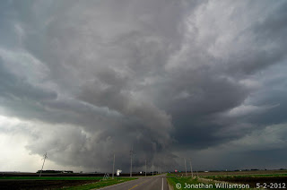
Wednesday, May 2, 2012
Amazing MN Tornadic Supercell! - 5-1-2012
What looked like a fairly mediocre setup with a solid dry air punch advecting in to kill storms turned into an incredible day as an isolated tornadic supercell rooted onto the warm front and dove east. Plenty of intense moments on the chase, including a point in Sauk City where traffic slowed us down enough to where the circulation crossed right overhead!
Here's a shot from my chase partner Jonathan Williamson...I'll have video up later. Chasing today in IA/SD/NE...hoping for some sort of outflow boundary magic.

Incredible inflow tail to the right, rapidly rotating wall cloud in the center, rear flank downdraft punch to the left.
Here's a shot from my chase partner Jonathan Williamson...I'll have video up later. Chasing today in IA/SD/NE...hoping for some sort of outflow boundary magic.

Incredible inflow tail to the right, rapidly rotating wall cloud in the center, rear flank downdraft punch to the left.
Monday, April 30, 2012
Chase Plans - May 1st, 2012
Heading north to Madison, WI in a couple hours, meeting up with a couple chasers there and heading up to Minnesota for tomorrow's setup. Concerned about the lack of appreciable upper level/500mb jet support, but it's close enough to be worth a play.
Ended up with about 3,400 miles over the last few days...brief tornado captured in eastern KS, nice structure all three days, but overall fairly underwhelming. Be nice to change that the next couple days...see if we're able to pull some magic out of the warm sector tomorrow!
Ended up with about 3,400 miles over the last few days...brief tornado captured in eastern KS, nice structure all three days, but overall fairly underwhelming. Be nice to change that the next couple days...see if we're able to pull some magic out of the warm sector tomorrow!
Wednesday, April 25, 2012
Chase update - 4-26/4-27-2012
Currently in West Memphis, TN, getting the Jetta some upgrades for what looks like a significant tornado threat over SE CO/SW KS/NW OK late tomorrow afternoon. Don't have time to post an updated forecast, but what I posted before is pretty much on track. Blasting west to OKC for the night, then NW tomorrow afternoon!
After that, looks like the 27th is going to be a warm front play in central MO...head up that way, then home Friday night/Saturday morning. Could be a couple of great days!
After that, looks like the 27th is going to be a warm front play in central MO...head up that way, then home Friday night/Saturday morning. Could be a couple of great days!
Saturday, April 21, 2012
Forecast: 4/27 - 4/28/2012
The long-range GFS model has been showing potential for severe weather/tornadoes towards the end of this coming week...here's a quick overview of the situation.


For the 27th, a strong dryline is forecast to set up over eastern Colorado down through west Texas.

500mb jet aoa 50 kts isn't fantastic, but will support supercell storm structures.

Bulk shear values at over 60 kts are forecast...more than sufficient for strong rotating supercells.

Gorgeous hodo...definitely suggests the possibility of strong tornadoes.
Only limiting factors with the GFS are CAPE and the possibility of warmer temps advecting in at 925 mb and creating a capping inversion...GFS normally underestimates CAPE, though, so that doesn't appear to be an issue. The cap, on the other hand, looks like it may be an issue both on the 27th and the 28th...we'll see how it plays out.
Afa the 28th is concerned, the setup is basically the same.

Dryline looks almost exactly the same...even in the same place as the day before! Biggest difference here is the hint of a low center developing in SE Colorado...if this happens, it should enhance directional shear in SW KS, especially.

Again, an absolutely gorgeous hodo right on the SW KS/OK border...if this verifies, strong tornadoes will again be a concern.

GFS is a bit more generous with the CAPE on the 28th...2500+ is more than enough to get sups rolling.
In essence, while still a ways out, and subject to change drastically...a rudimentary look at the weather models are sufficient to show that a significant severe weather outbreak could occur late next week over the southern plains...I'll be on leave for a couple weeks starting this week, so I'll definitely be playing these setups!
Tuesday, April 17, 2012
Sunday, April 15, 2012
5 tornadoes! - 4/14/12 KS/OK tornado outbreak
Snagged 5 tornadoes today, including twice where we had two on the ground at once. Intense day...awesome structure led to frustration early on as the first 5 storms just couldn't do it...then ended up getting chased down the worst roads I've ever driven in by an incredible 400 yard wide multi-vortex tornado within 100 yards. Working on video now - it's sick. Here's a few shots...didn't get good stills of the tornadoes - just too much going on.

Incredible wall cloud in SW KS.

Tornado #1 back in the rain...ended up being a gorgeous elephant trunk.

Close-up of the wall cloud.


One of the tornadoes in Major county, OK.
Video to follow!

Incredible wall cloud in SW KS.

Tornado #1 back in the rain...ended up being a gorgeous elephant trunk.

Close-up of the wall cloud.

This was our last shot before all hell broke loose...closest I've ever come to being hit on a chase. 100 yards.

One of the tornadoes in Major county, OK.
Video to follow!
Friday, April 13, 2012
Update - Chase Plans, 4-14-12
Tomorrow is one of those days that just looks absolutely scary...forecast I posted below has verified in every regard - in fact, it's actually gotten stronger. Leaving in a couple hours - 14 hour drive through the night to OKC, get there about 4 AM, sleep for 5 hours, thinking about heading up to Wellington, KS after that. Going to have to marathon it back to Pensacola Saturday night/Sunday...should be able to pull it off non-stop.
OKC metro - Wichita metro and points in between...wow. Loaded gun setup, potentially historic tornado outbreak unfolding. One of those chase days where you have a sick feeling in your stomach as you watch it all come together. Area up at the triple point in NE/IA also looks dangerous.
I'll post some nowcast updates as data permits...time to make it 3-3 for wedges on high risk days.
Sunday, April 8, 2012
Forecast - 4-14-2012
As per the morning's GFS runs, potential exists for a large-scale tornado outbreak Saturday, April 14th. Currently looking at a target just west of OKC...could shift as the smaller-scale models come into focus towards the end of the week.

Taking a look at the surface wind/temps map, two areas of interest pop out, associated with the lows centered in eastern Colorado and SW Minnesota.

Map of the surface moisture/dewpoints show a well-defined dryline extending from southern MN all the way south to Mexico.

Absolutely gorgeous sickle hodograph taken at 00Z just west of the OKC metro area. Bulk shear values and SRH (storm relative helicity) are going to be more than sufficient if this verifies.

Nice pocket of 2500-3000 CAPE (convective available potential energy) right in my target area...CAPE will be sufficient in the secondary area of interest in NC IA/SC MN, to boot.
In essence, Saturday has the potential to be a large-impact, dangerous tornado outbreak ranging from Texas to Minnesota. Attm, expecting to be just northwest of the OKC metro area Saturday afternoon...obviously, that could change as this gets closer to fruition. My official 2 week "chasecation" begins April 17th...will be chasing every setup!
Thursday, March 1, 2012
Major Dixie Alley Tornado Outbreak - March 2-3, 2012
A classic and potentially historic tornado outbreak is setting up for tomorrow into Saturday for areas from Kentucky southward. Shear, helicity, CAPE, directional turning, dews, and a strong low pressure area are combining to create one of the most potent severe weather setups that I've personally ever seen. Below is quoted from the National Weather Service Office in Nashville's AFD:
"A BIG SEVERE WX OUTBREAK IS EXPECTED FOR MID TN FRIDAY. STRONG LONG TRACK TORNADOES...DAMAGING WINDS AND LARGE HAIL ARE ALL POSSIBLE. SPC CONTINUES TO POST A MODERATE RISK FOR SEVERE WEATHER OVER THE MID STATE. THIS EVENT LOOKS MORE WIDESPREAD AND SUBSTANTIAL THAN THE SEVERE THREAT WE HAD YESTERDAY...PROBABLY THE BIGGEST OUTBREAK OF TORNADOES SINCE APRIL 27, 2011. THIS EVENT COULD BE ONE OF THE GREATER IMPACT EVENTS IN THE PAST FEW YEARS."
Don't see wording like this often at all - and this isn't exaggerated a bit. I'll have to re-evaluate the situation after I get off tomorrow aoa 1900, but at this point, I'm planning on blasting north to around Birmingham to see what I can snag overnight. Points from Indianapolis south to the Gulf, watch out.
Thursday, February 16, 2012
First Chase of 2012!
Putting together a team for the first chase of 2012 this Saturday! Still working on the forecast,but looks like we could get a few discrete supercells ahead of a developing MCS in southern MS/AL. Initial target looks to be Hattiesburg, MS...strong 500 mb bulk shear values of 90 kts, extremely favorable clockwise hodographs, CAPE aoa 1500 j/kg, etc...could be a couple nice tornadoes! I'll update as the situation warrants.
Subscribe to:
Posts (Atom)